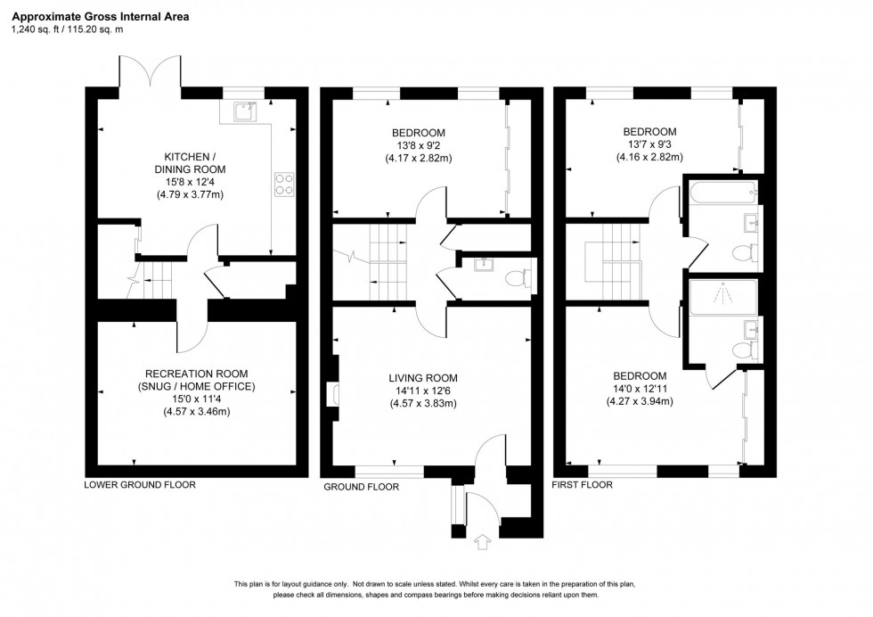
4 Bed House For Sale
Hanbury Lane, Haywards Heath, RH16
Guide Price £425,000 (Freehold)
- A beautiful home with numerous upgrades
- Refitted cloakroom and en-suite shower room
- Double-width private driveway for 2 cars
- 35' x 21' fully enclosed rear garden
- Ground: Porch, lounge, bedroom 3 & WC
- Lower Ground: kitchen/breakfast room & recreation room/cinema
- 1st: Master bedroom with en-suite, bed 2 & bathroom
- Easy walk to Lindfield Village High Street - 1 mile walk to railway station
- Walking distance of several schools
- For sale with no onward chain - Estate Charge: currently £290 per year
GUIDE PRICE … £425,000-£450,000
PLEASE WATCH THE VIDEO BEFORE BOOKING AN APPOINTMENT
An upgraded 3 double bedroom end of terrace 3 storey house of 1240 sq ft situated on the Haywards Heath/Lindfield borders, almost backing onto the Scrase Valley Nature Reserve, within walking distance of local shops, schools, the railway station and Lindfield's picturesque village High Street.
Location Summary
Hanbury Lane is a continuation of Washington Road leading off Oathall Avenue on the rejuvenated east side of town, ideally placed on the Haywards Heath/Lindfield borders. Haywards Heath’s mainline railway station is within a mile and provides fast commuter links to London (Victoria/London Bridge 47 mins), Gatwick Airport (15 mins) and the south coast (Brighton 20 mins). A pathway just to the west leads through the Scrase Valley Nature Reserve and offers swift pedestrian access through to Lindfield’s picturesque High Street and Common where there is a traditional range of shops, pubs, boutiques, restaurants and cafes. Local facilities include; a parade of shops in nearby America Lane and the greatly improved Warden Park Primary Academy School. Haywards Heath town centre is within a mile and offers an extensive range of shops, stores, restaurants, cafes, bars, 6th form college and leisure centre. A regular bus service runs along Hanbury Lane linking with the town centre, station and neighbouring districts. By road, access to the major surrounding areas can be gained via the B2036, the A272 and the A/M23, the latter lying approximately 6 miles to the west at Bolney or Warninglid.
Distances (in miles approx. on foot, by car, train)
Warden Park Primary Academy (0.7) Children attending the Primary Academy can go on to attend Warden Park Secondary Academy in Cuckfield
St Wilfrid’s Primary (0.9)
Blackthorns & Lindfield (both 0.7)
St Joseph’s RC Primary (0.9)
Warden Park (Secondary) Academy in Cuckfield (2.5)
Oathall Community College (closest Secondary School - 0.4)
St Paul’s RC Secondary College in Burgess Hill (5.0)
Railway station 1.0 (via Clair Park)
A23 Bolney 6
Gatwick Airport 16
Brighton seafront 14
Council Tax Band: D
Nearest Stations
- Haywards Heath - 0.82miles
- Wivelsfield - 3.08miles
- Horsted Keynes (Bluebell Railway) - 3.47miles
- Sheffield Park (Bluebell Railway) - 3.72miles
- Burgess Hill - 3.86miles
Location
Floorplans